Competency Area 6: Watershed hydrology AEM
PO 57. Understand the major inputs and outputs of water in a watershed.
Similar to the concepts discussed in Competency Area 2: Soil Hydrology, the components of the hydrologic cycle and the water budget for the soil profile can be applied to watersheds. Some differences in these concepts need to be considered, however, because of the larger scale and spatial variations that occur in watersheds, especially as they become larger.
In watersheds, the spatial distribution of elevations, soils, geology, vegetation, and land use interact with the hydrologic cycle, causing variations with how water collects, drains, and is redistributed within soil associations and throughout the landscape.
In the Soil Survey, distinctive patterns of soils, elevation relief, and drainage are commonly grouped by their association. For example, the following figure shows a typical relationship of soils and underlying geologic material in the Hudson-Rhinebeck-Manlius general soil association map unit (From Soil Survey of Saratoga County, New York).
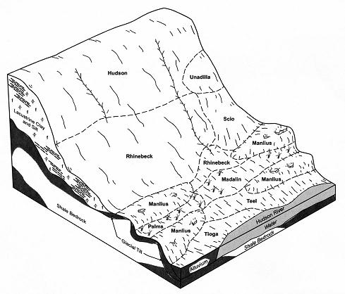
image source: NRCCA Soil and Water Management Study Guide
This general soil association is further described in the survey as gently sloping to hilly with scattered rock outcrops in the Manlius part of the unit. Large watersheds commonly consist of a composite of these general soil associations, creating further complexity in watershed hydrology.
Quick Links
- Competency Area 1: Basic soil properties
- Competency Area 2: Soil hydrology AEM
- Competency Area 3: Drainage and irrigation AEM
- Competency Area 4: Soil health and compaction
- Competency Area 5: Soil conservation AEM
- Competency Area 6: Watershed hydrology AEM
- Competency Area 7: Non-point source pollution AEM
- Competency Area 8: Concentrated source pollution AEM
- Competency Area 9: Conservation planning AEM